
Interim-Management + ConsultingInterim Management + Consulting

3D Laser-Scanning3D Laser-Scanning

in Logistik, Real Estate & Produktionin Logistics, Real Estate & Manufacturing

Vom physischen Standort zum digitalen Zwilling.
Erste Ergebnisse:24–36 Stunden.
From physical site to digital twin.
First results:24–36 hours.

Savings-Potenzial:
1. Nacharbeitskosten: −5 bis −15 %,
2. Reisekosten:−30 bis −50 %.
Savings Potential:
1. Rework costs: −5 to −15%,
2. Travel costs:−30 to −50%.
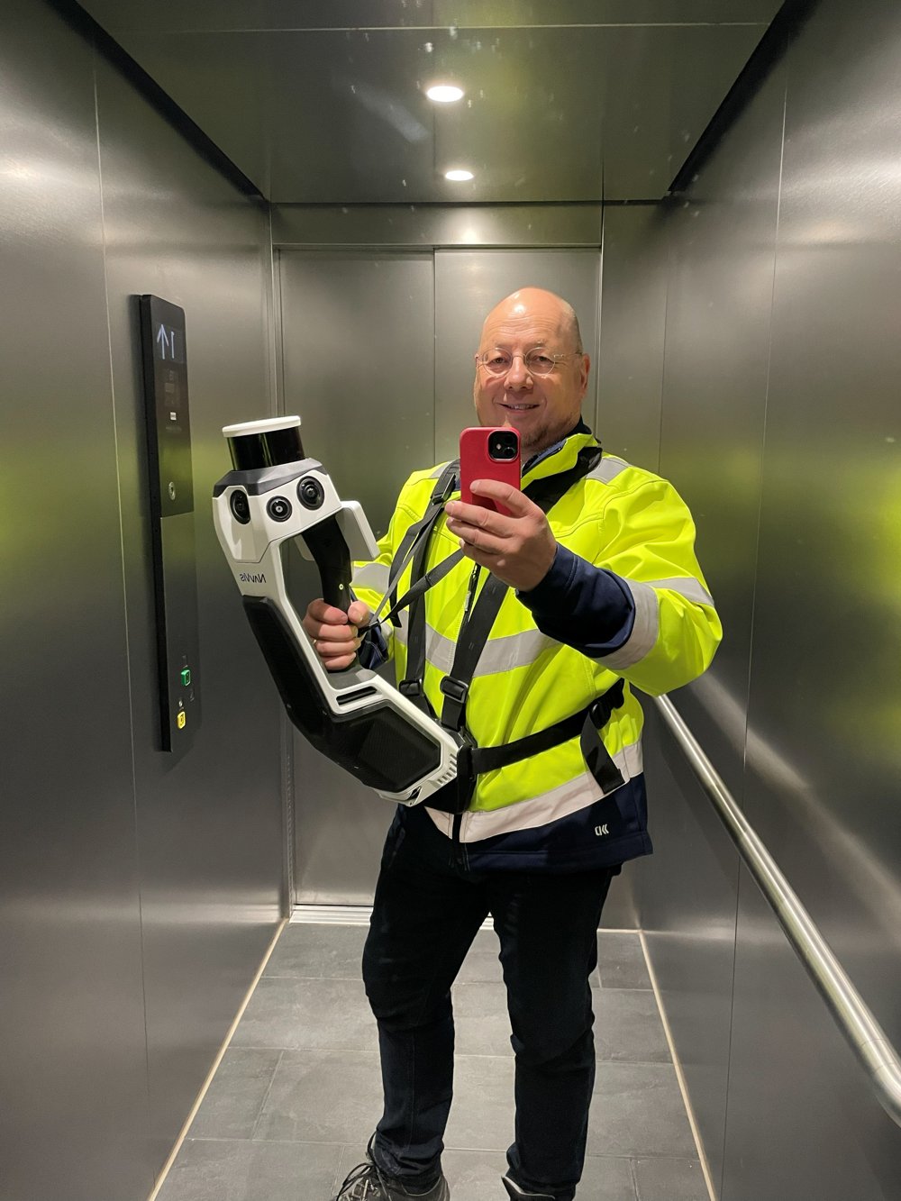
Björn Bünemann mit NavVis MLX SLAM-Laserscanner
High Tech meets Operations – NavVis MLX SLAM-Laserscanner im EinsatzHigh Tech meets Operations – NavVis MLX SLAM laser scanner in action
Management SummaryManagement Summary

Auf einen BlickAt a Glance

1

Vielen Logistik- und Produktionsstandorten fehlen aktuelle Standortpläne. Dies führt u. a. zu operativen und kaufmännischen Ineffizienzen, Risiken und Hindernissen bei Planungen.Many logistics and production sites lack up-to-date site plans. Among other aspects, this leads to operational and commercial inefficiencies, risks and obstacles in planning.

2

3D Laser-Scanning führt innerhalb von 24–36 Stunden zu einem präzisen digitalen Zwilling. Danach ist der Standort mit 360°-Panoramabildern visualisiert und online begehbar.3D laser-scanning delivers a precise digital twin within 24–36 hours. The site is then visualized with 360° panoramic images and walkable online.

3

In der Punktwolke kann gemessen werden.Measurements can be taken directly in the point cloud.

4

Optional können 2D-Grundrisse, 3D- und BIM-Modelle erstellt werden.2D floor plans, 3D- and BIM-models can optionally be created.

5

Use Cases: CL- und Road-Operations, Real Estate, Projekt-Management, Business Development und Emergency-Response.Use cases: contract logistics & road operations, real estate, project management, business development and emergency response.

6

3D Laser-Scanning kann entweder stand-alone oder in Verbindung mit Interim-/Projekt-Management beauftragt werden.3D laser-scanning can be commissioned either as a standalone service or combined with interim/project management.
24–36 Std.hrs
Schnell & sehr störungsarmFast & minimally disruptive
Ist-Aufnahme des gesamten Standortes im laufenden Betrieb.Full as-is capture of a site during running operations.
± 5–25 mm
PräzisionPrecision
Genauigkeit (LoA) bei > 98 % der Daten – ausreichend für sehr viele Anwendungsfälle.Level of accuracy (LoA) for > 98% of the data – sufficient for a wide range of use cases.
6 Clusterclusters
für Use-Casesfor use cases
EINE Datenbasis für Operations, Real Estate, Finance/Legal, Projekt-Management, BD, Emergency-Response.ONE data foundation for operations, real estate, finance/legal, project management, BD, emergency response.
01 — PROBLEM01 — PROBLEM
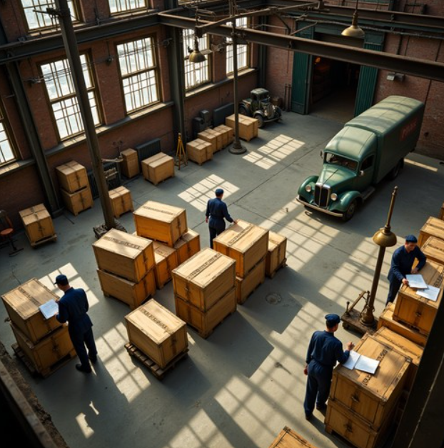
Altes Lager ohne aktuelle Pläne – Mitarbeiter bei der manuellen Inventur zwischen Kisten
01 — Problem01 — Problem

Kein aktuelles Abbild der RealitätNo up-to-date picture

Logistik- und Produktionsstandorte arbeiten oft mit veralteten oder fehlenden Plänen. Logistics and production sites often work with outdated or missing layouts.

Die Folge: ungenutztes Potenzial, Sicherheitsrisiken und teure Planungsschleifen – weil das Business keine verlässlichen Daten zur Verfügung hat. The result: unused potential, safety risks and costly planning loops – because the business runs on an unreliable data foundation.

02 — Lösung02 — Solution

Ein Scan. Ein digitaler Zwilling.One scan. One digital twin.

Laserstrahlen erfassen Millionen Punkte zu einer Punktwolke inkl. 360°-Panoramabildern. Laser beams capture millions of points into a point cloud, including 360° panoramic images.

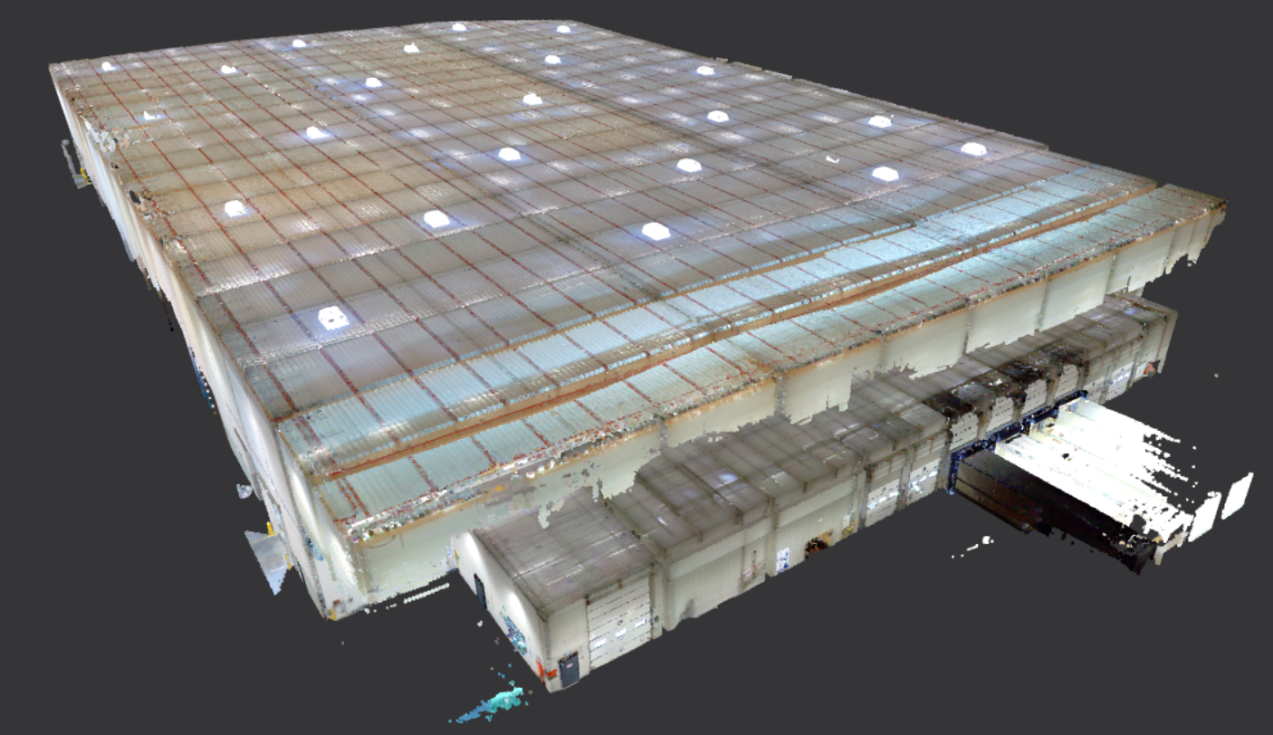
Daraus entsteht ein realitätsgetreues 3D-Modell – der Standort wird virtuell begehbar, wie in Google Street View. Die Daten sind beliebig oft nutzbar. This creates a true-to-life 3D-model – the site becomes virtually walkable, like in Google Street View. The data can be used as often as needed.

03 — Benefits03 — Benefits

Ein Scan, viele HebelOne scan, many levers

Layouts erstellen, direkt in der Punktwolke messen, online visualisieren, Compliance sichern sowie Kosten, Fehler und Iterationen reduzieren. Create layouts, measure directly in the point cloud, visualize online, ensure compliance, and reduce costs, errors and iterations.

Ein Scan liefert Hebel für Betrieb, Planung, Reporting, Entscheidung und Kommunikation. One scan delivers levers for operations, planning, reporting, decisions and communication.

04 — Use Cases04 — Use Cases

Eine Datenbasis, sechs AnwendungsfelderOne data foundation, six fields of application

Ein einziger Scan liefert die Grundlage für viele verschiedene wertvolle Anwendungsfälle. A single scan provides the foundation for many different valuable use cases.

05 — Ablauf05 — Workflow

Ergebnis in 24–36 StundenResults within 24–36 hours

Scan vor Ort, System-Verarbeitung der Rohdaten, dann Online-Zugang zu Punktwolke und Panoramafotos – das Mindestergebnis liegt innerhalb von 24 bis 36 Stunden vor. On-site scan, system processing of the raw data, then online access to the point cloud and panoramic photos – the minimum result is available within 24 to 36 hours.

2D-Grundrisse und BIM-Modelle sind optional und aufbauend buchbar. 2D floor plans and BIM-models are optional add-ons.

Benefits im DetailBenefits in Detail

Ein Scan liefert viele Hebel für Betrieb, Planung, Reporting, Entscheidung und KommunikationOne scan delivers many levers for operations, planning, reporting, decisions and communication

Layouts: erstellenLayouts: create

  • Aktuelle Grundrisse/Layouts für jeden Standort liefern eine akkurate Grundlage zur Validierung, Optimierung und Planung.Up-to-date floor plans/layouts for every site provide an accurate basis for validation, optimization and planning.

Messen: ermöglichenMeasuring: enable

  • Beliebig viele Maße – Abstände, Längen, Breiten, Höhen, Flächen – direkt in der Punktwolke messen.Take any number of measurements – distances, lengths, widths, heights, areas – directly in the point cloud.

Visualisierung: onlineVisualization: online

  • Virtuelle Tour inkl. 360°-Panoramabilder, weltweiter Zugang.Virtual tour incl. 360° panoramic images, worldwide access.
  • Konkrete Abstimmungen (online via Teams) auf allen Managementebenen – inkl. Kunden und Lieferanten.Concrete alignment (online via Teams) at all management levels – including customers and suppliers.

Compliance: sichernCompliance: ensure

  • Dokumentation erlaubt „one truth" – inkl. Versionierung.Documentation enables a single "one truth" – including versioning.
  • Dauerhaft überprüfbarer Ist-Zustand für rechtliche Nachweise ermöglicht aktives Risk-Management.A permanently verifiable as-is status supports legal evidence and active risk management.
  • Grundlage für Flucht-/Rettungswege, Brandschutz, Audits.Basis for escape/emergency routes, fire protection, audits.

Kosten und Fehler: reduzierenCosts and errors: reduce

  • Prozessoptimierungen in Operations, Arbeitssicherheit und Compliance.Process optimization in operations, occupational safety and compliance.
  • Trainings und Schulungen, 5S.Training and coaching, 5S.
  • Vermeidung von Nacharbeiten, frühzeitiges Erkennen von Kollisionen.Avoidance of rework, early detection of collisions.
  • Reduzierung menschlicher Messfehler.Reduction of human measurement errors.

Effizienz: steigernEfficiency: increase

  • Iterationen nehmen ab, Planungsgeschwindigkeit und Motivation steigen.Fewer iterations, higher planning speed and motivation.
  • Kundenvertrauen nimmt zu, positive und innovative Wahrnehmung am Markt wird gestärkt.Increased customer trust, stronger positive and innovative market perception.
  • Wiederverwendbare Datengrundlage.Reusable data foundation.
Use Cases im Detail – für Logistik und ProduktionUse Cases in Detail – for Logistics and Production

Von der Halle bis zur Brücke – ein Datensatz, viele AnwendungenFrom the warehouse to the bridge – one dataset, many applications

OperationsOperations

Contract Logistics & RoadContract Logistics & Road
  • Layouts und Grundrisse erstellenCreate layouts and floor plans
  • Flächen analysieren (leer, belegt, Wegbreiten)Analyze areas (vacant, occupied, aisle widths)
  • Abgleich mit MietverträgenCompare against lease agreements
Oversize TransportOversize Transport
  • Brücken-, Straßen- und LichtraumprofileBridge, road and clearance profiles

Real EstateReal Estate

  • Maintenance und ReparaturenMaintenance and repairs
  • Doku: Übernahme / Übergabe von GebäudenDocumentation: building handover / transfer
  • AbrissplanungDemolition planning
  • Vergabeprozess beim Einkauf von DienstleistungenVendor selection for service procurement
  • Drohnendaten integrierenIntegrate drone data

Projekt-ManagementProject Management

  • Task-ManagementTask management
  • Virtuelle Projekt- und BaubesprechungenVirtual project and construction meetings
  • Identifikation von PlanungsfehlernIdentification of planning errors

Finance, Versicherung + LegalFinance, Insurance & Legal

  • Update von ReportingsReporting updates
  • KPIKPIs
  • Kosten- und ProfitallokationenCost and profit allocation
  • Claim-ManagementClaims management
  • Support bei der Erstellung von Immobilien-PolicenSupport in preparing property insurance policies
  • Audits online durchführenConduct audits online

BD / KundenBD / Clients

  • Brownfield: RFQ-UnterstützungBrownfield: RFQ support
  • Integration von geplanter GebäudeausstattungIntegration of planned building fit-out
  • 3D-Tour mit Management und Kunden3D tour with management and clients

24/7 Emergency-Response24/7 Emergency Response

  • Schadens-Dokumentation bei UnfällenDamage documentation after accidents
  • BeweisaufnahmenEvidence collection
Ablauf im DetailWorkflow in Detail

Wer ist woran beteiligt?Who is involved in what?

Von der Rohdatenerfassung bis zum fertigen 2D-/3D-Modell. Der Grad der Kundenbeteiligung hängt von Know-how, Ressourcen und Software-Strategie ab.From raw data capture to the finished 2D-/3D-model. The degree of customer involvement depends on know-how, resources and software strategy.

1
Scan-Prozess inkl. System-Verarbeitung der Rohdaten (NavVis + Ivion)
Scanning process incl. system processing of raw data (NavVis + Ivion)
Stundenhours
Bünemann Interim
KundeCustomerZiel ausrichten + Facility vorbereitenAlign target + prepare facility
ExternExternal
2
Zugang zu Ansicht + Messung in Punktwolke und Panorama-Fotos (NavVis in Ivion)
Access to view + measure in point cloud and panoramic photos (NavVis in Ivion)
24–36 Std.hrs
Bünemann Interim
KundeCustomerDatei-Download (*.e57) oder Ivion-ZugangFile download (*.e57) or Ivion access
ExternExternalDatei-Download (*.e57) oder Ivion-ZugangFile download (*.e57) or Ivion access
3
Integration externer Datenmodelle in die Scan-Daten (ifc / dxf → Ivion)
Integration of external data models into the scan data (ifc / dxf → Ivion)
Stundenhours
Bünemann Interim
KundeCustomer
ExternExternal
4
Manuelle Erstellung eines individuellen Grundrisses (*.dwg) (Ivion / CAD-Tools, z. B. BricsCAD)
Manual creation of a custom floor plan (*.dwg) (Ivion / CAD tools, e.g. BricsCAD)
Tagedays
Bünemann Interimselbst oder über Externin-house or via external partner
KundeCustomer
ExternExternal
5
Manuelle Erstellung komplexer 2D-/3D-Zeichnungen oder BIM-Modelle (CAD-/BIM-Tools, z. B. Revit, BricsCAD)
Manual creation of complex 2D-/3D-drawings or BIM-models (CAD/BIM tools, e.g. Revit, BricsCAD)
Wochenweeks
Bünemann Interimüber Externvia external partner
KundeCustomer
ExternExternal
World Class EquipmentWorld Class Equipment

NavVis MLX SLAM-ScannerNavVis MLX SLAM Scanner

Ein mobiler SLAM-Scanner wird bewusst anstelle eines terrestrischen Scanners eingesetzt:A mobile SLAM scanner is deliberately used instead of a terrestrial scanner:
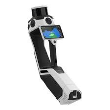
NavVis MLX SLAM-Laserscanner freigestellt
  • Exzellentes Verhältnis aus Genauigkeit, Investitionskosten und Geschwindigkeit ("Mobile Mapping") vor Ort.Excellent ratio of accuracy, investment cost and speed ("mobile mapping") on site.
  • Minimale Störung der Logistik- und Produktionsprozesse während des Scannens.Minimal disruption to logistics and production processes during scanning.
  • Hohe Flexibilität im operativen Einsatz.High flexibility in operational use.
PraxisbeispieleExamples

3D Laser-Scanning in Action3D Laser-Scanning in Action

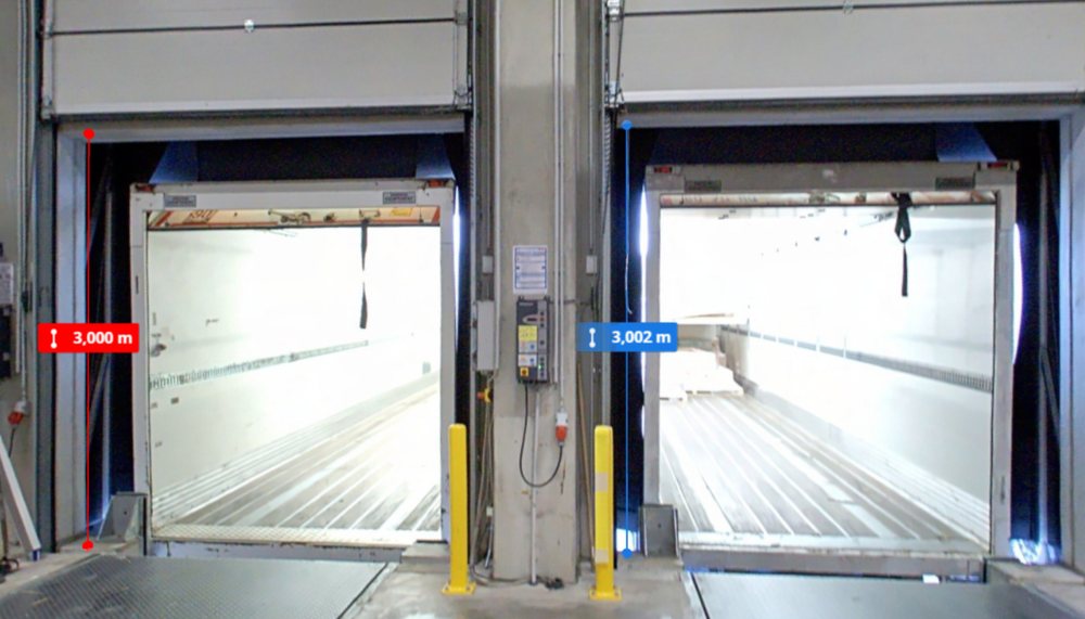
Messung von Breiten und Flächen an Hallentoren in der Punktwolke

Beliebiges und wiederholbares Messen vonFlexible and repeatable measuring of
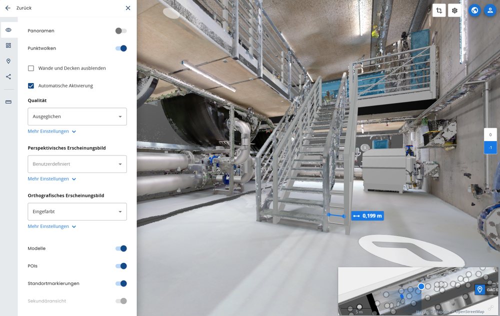
  • Breitenwidths
  • Höhenheights
  • Längen undlengths and
  • Flächen.areas.
IFC-Modell einer geplanten Anlage in Scan-Daten integriert

Integration von *.ifc-Modellen geplanter Anlagen in die erfassten Scan-Daten.Integrate *.ifc models of planned equipment into the captured scan data.
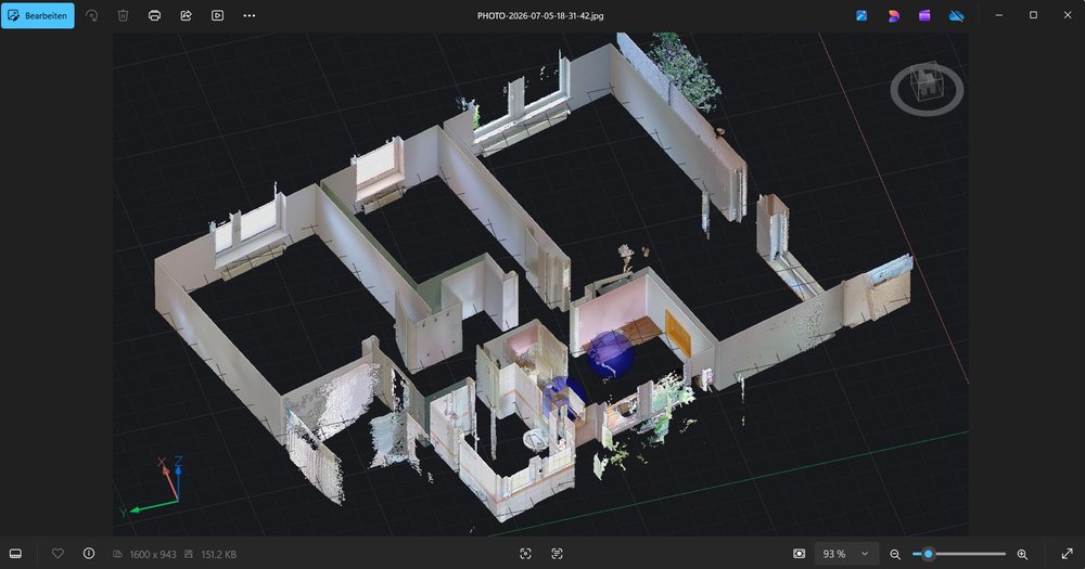
  • Machbarkeit prüfenValidate feasibility
  • Abweichungen erkennenIdentify deviations
  • Iterationen reduzierenReduce iterations
Grundriss für eine Hallenplanung in BricsCAD abgeleitet

Ableitung eines Grundrisses fürDeriving a floor plan for
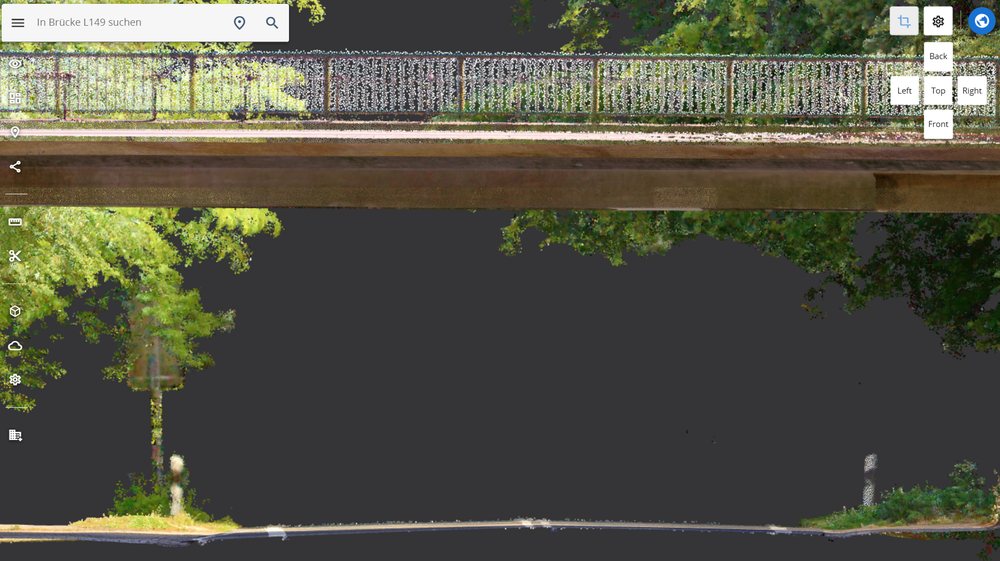
  • Büro- oderoffice or
  • Hallenplanung (BricsCAD).warehouse planning (BricsCAD).
Punktwolke eines Straßenprofils unter einer Brücke

Analyse des Straßenprofils.Analyze road profile.
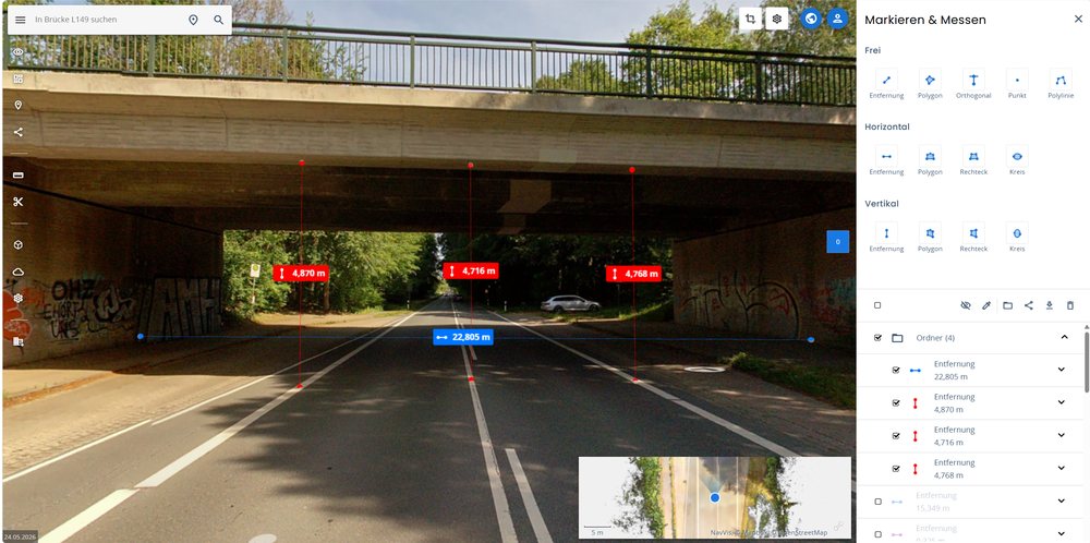
Messung von Durchfahrtshöhe und -breite an einer Unterführung

Messung vonMeasure

  • Durchfahrtshöhen undclearance heights and
  • -breiten.widths.
EinordnungComparison

Interim Management vs.
Vermessung
Interim Management vs.
Surveying

Beides hat seine Berechtigung und kann sich gut ergänzen. Je nach Bedarf.Both have their place and can complement each other well. Depending on the need.

Die unmittelbare Kombination aber aus SLAM-Scanning und Interim- sowie
Projekt‑Management schafft besonderen Mehrwert.
But the direct combination of SLAM scanning with interim and project management creates special added value.

High Tech meets Operations.High Tech meets Operations.

Der zusätzliche Blick auf oder in eine Halle und einen Betrieb erlaubt vielfältige Möglichkeiten der Optimierung in Verbindung mit den Ergebnissen aus dem 3D Laser-Scanning.The additional view onto or into a warehouse and operation opens up a wide range of optimization possibilities in combination with the results from 3D laser scanning.

BÜNEMANN INTERIMBÜNEMANN INTERIM
VERMESSER / 3D-ENGINEERINGSURVEYOR / 3D ENGINEERING
SLAM-ScanningSLAM Scanning
BÜNEMANN INTERIM Die erzielte Scan-Genauigkeit ist technisch identisch!The achieved scan accuracy is technically identical! Vermesser / 3D-Eng.
2D-Grundriss / Layout2D floor plan / layout
BÜNEMANN INTERIMindividuell auf den operativen Bedarf in Logistik / Produktion zugeschnittenindividually tailored to operational needs in logistics / production
Vermesser / 3D-Eng.oft nach DIN 277 – dadurch oftmals mehr Aufwand als rein operativ nötig, häufig verbunden mit höheren Kostenoften per DIN 277 – as a result, frequently more effort than operationally necessary, often associated with higher costs
Komplexe 3D-/BIM-ModelleComplex 3D-/BIM-models
BÜNEMANN INTERIMüber Externvia external partner
Vermesser / 3D-Eng.intern oder über Externin-house or via external partner
Logistik-Know-howLogistics know-how
BÜNEMANN INTERIMOpportunity für direkten logistischen MehrwertOpportunity for direct logistics value-add
Vermesser / 3D-Eng.
Terrestrisches Scanning / technische VermessungTerrestrial scanning / technical surveying
BÜNEMANN INTERIM
Vermesser / 3D-Eng.sofern (sub-)mm-Genauigkeit absolut erforderlich istif (sub-)mm accuracy is absolutely required
Integration ins LeistungsportfolioPart of the service portfolio

Ergänzend zu meinem bestehenden LeistungsportfolioAs a complement to my existing service portfolio

biete ich an:I offer:

3D Laser-Scanning kann entweder in Verbindung mit den vorgenannten Services
oder Stand-alone gebucht werden.
3D Laser-Scanning can be booked either in combination with the aforementioned services
or standalone.
KontaktContact

Lass uns sprechen!Let's talk!

Vom physischen Standort zum digitalen Zwilling
in 24–36 Stunden.
From physical site to digital twin
within 24–36 hours.